loader
Join Free
Views: 82 Updated: 12.04.23 Posted: 10.27.23 Status: Inactive

Summary

Price $2,208,000
Built/Renov 1996/2017
Tenant Denny's
Cap Rate 5.50%
Lease Type NN+
Guarantor Franchisee
Size/SF 4,582
Lease Start 05-01-2018
#Units 35
Price/SF $481.89
Expiration 10-30-2038
Tenant Type Casual Dining
NOI $121,423
R. Term 13.9
Ownership Fee Simple
Rent/SF $26.50
Increases 7.0%/5/yrs
Pop 5Mi 147,213
Lot/AC 0.70
Options 4/5yrs/7%
AHHI 5Mi $66,703

Lease Highlights

  • Denny’s has 15 years remaining on the base term with 4 (5-year) options to extend
  • The lease features 7% rental increases every 5 years, beginning on 11/1/28
  • Favorable NN+ lease with landlord responsibilities limited to roof & structure
  • Lease is backed by RJC, LLC | Experienced 32-unit Denny’s operator
  • Tennessee has no state income tax

Location Description

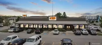
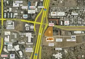
The subject property is strategically located, with excellent visibility and access along Broadway/Hwy 71 which sees 80,000+ vehicles passing by daily. It is directly across the street from a Food City, Harbor Freight Tools, and Planet Fitness-anchored shopping center, and just over half a mile from 1-640 (79,000+ VPD). In addition, Denny's is about a mile from Knoxville Central High School...

...

Maps

  • 1 Mile
  • 3 Miles
  • 5 Miles

Tenant

About Tenant

Denny's, or Denny's Corp (NASDAQ: DENN), is one of America’s largest full-service restaurant chains based on number of restaurants. Founded by Harold Butler and Richard Jezak, who opened...


...

Demographics

  1 Miles 3 Miles 5 Miles
2028 Total Population : 6,868 60,852 150,593
2023 Total Population : 6,794 60,108 148,227
2023 Employed Civilian Pop : 3,524 29,378 69,512
2023 Total Businesses : 479 1,840 5,959
2023 Average Household Income : $ 68,658 $ 68,932 $ 68,371
2023 Total Consumer Spending : $ 195 M $ 1645 M $ 3789 M
2023 Median Age : 42 40 38
2023 Total Households : 3,243 27,209 63,182
2023 Pop Age 25+: Bachelor's Degree : 1,035 8,706 19,596
2023 Average Home Value : $ 272,652 $ 276,758 $ 278,442
*ESRI data is presented for informational purposes only

Traffic

Collection Street Cross Street Year Traffic Vol Distance
US 441 Harvest Mill Way 2021 34,641 0.07 mi
N Broadway Woodrow Dr 2005 43,840 0.15 mi
ADAIR DR.-KNOXVILLE N Broadway 2019 5,486 0.15 mi
Tazewell Pike McCamey Rd 2005 19,730 0.23 mi
ADAIR DR. N Broadway 2021 5,451 0.26 mi
Rennoc Rd NE Tillery Ln NE 2005 1,237 0.27 mi
Highland Dr N Broadway 2005 3,741 0.27 mi
SR 331 N Broadway St 2021 16,145 0.37 mi
SR 331 Smithwood Rd 2021 15,780 0.39 mi
Knox Rd NE Maple Dr NE 2005 5,126 0.45 mi

Listing Broker

Loading...
Disclaimer & Confidentiality
All information, content, data, and other materials on this Platform (“Content”) is made available to you on an “AS IS” basis without warranties of any kind, express or implied. All such Content is made available for informational purposes only and should not be relied on by you for any purpose. Content may contain errors, may be inaccurate or incomplete and/or, due to changing circumstances or other causes, may change or ultimately prove to be inaccurate or incomplete. Other than as set forth in our Terms of Service we do not have any control over your use of our Services or any Content. You should not use any such Services or any Content without validating the results through independent research, obtaining up-to-date information, and considering all relevant facts and circumstances, including your specific situation (financial or otherwise). We do not recommend, guarantee, or represent that the Services or any Content will predict the future performance of real estate assets or other assets of any kind. Moreover, we do not warrant the performance or results that may be obtained by using any of the foregoing. WE ARE NOT ENGAGED IN RENDERING TAX, LEGAL, INVESTMENT, FINANCIAL OR RISK MANAGEMENT ADVICE, AND THE RESULTS OF USE OF OUR SERVICES AND ANY CONTENT MUST NOT BE REGARDED OR REPRESENTED AS CONSTITUTING SUCH ADVICE. WE DO NOT MAKE ANY REPRESENTATIONS OR WARRANTIES REGARDING THE ACCURACY OF ANY CONTENT AND/OR PROJECTIONS GENERATED BY THE SERVICES OR ANY CONTENT

GET IN TOUCH

my activity